
A Search for Siemens Built Railways of Gedabey
– Almost all of them are in the site working busily in noisy, perhaps disturbing environment.
– They are used to that condition.
– Perhaps, also, my notion of disturbance is strange to them. I mean…they would be disturbed if I were to tell to them that ‘it is disturbing, isn’t it?’
– In other words, that is the way in which they earn their life.
– I have never been fully into that milieu.
– I resisted being a part of.
– In contrast, it is all quite in the camp.
– There is dead silence in the guest room where I always do my work.
– I continue doing translation of Cyanide Procedures of ICMI for the Gedabey Mine.
– I better take a break.
– Looking out through the door, I see no movement. People rarely walk in corridor afternoon.
– Looking out through the window, I see nice weather: partly cloudy, moderate sunshine, summer breeze blowing.
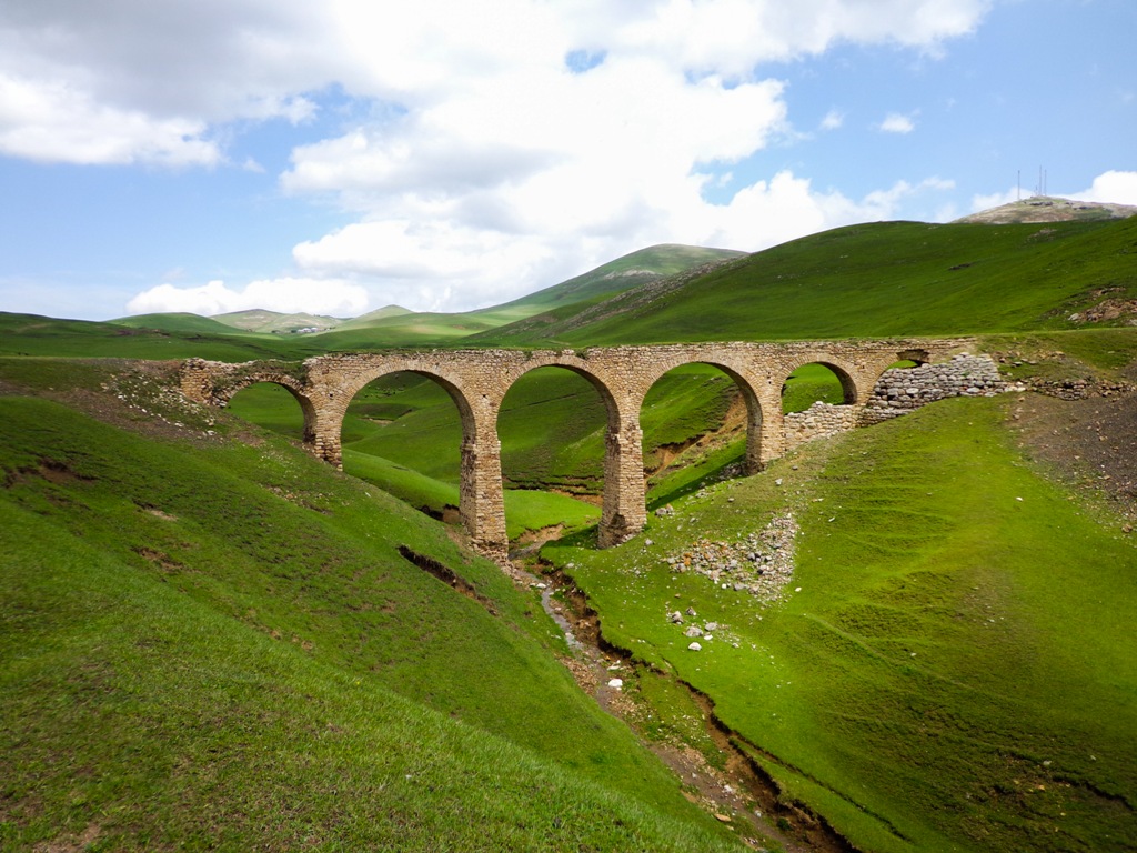
– Looking in through the Windows, I see the shadow of the bridge.
– This is so-called ‘bloody bridge’ in Duzyurd village.
– Ohh look here, another one.
– Wait a minute…these two are connected. Unidentified path leads one to another.
– I trace the path. It tracks me all the way to Galakent.
– I trace it backward. It tracks me to Gedabey mine.
– I trace it more. It takes me 130 years back in time.
Story of Gedabey’s Railways: A German Heritage in Azerbaijan
There is also a railway carried over a lofty viaduct, connecting the branch smelting establishment of Kalakent, some twenty miles off, with Kedabeg and the neighbouring metalliferous mountain.
Werner von Siemens. Personal Recollection of Werner von Siemens. 1893, pp. 280-281.
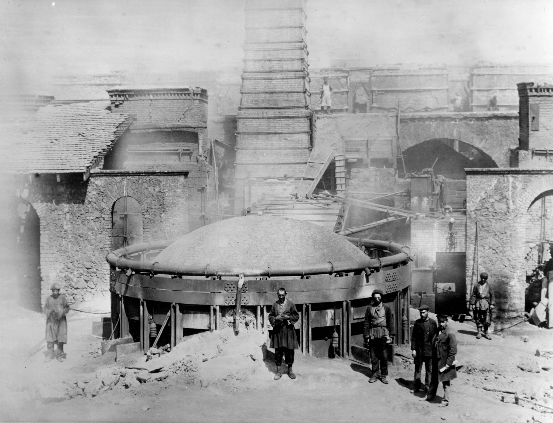
There were Copper Smeltery Plants and a Mine which had been operated by the Siemens Brothers Co. during 1865-1920.
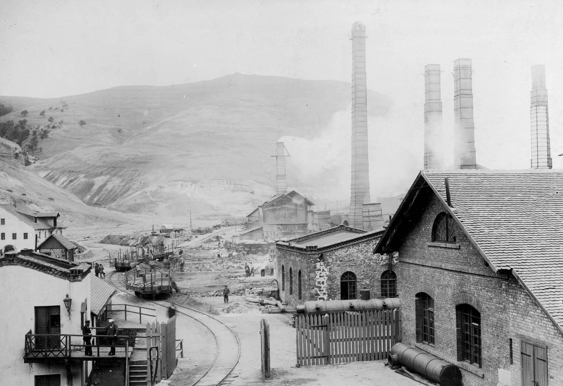
Thanks to the Siemens Brothers’ innovative approach and utilization of high-tech of the time, the mining industry in Gedabey turned to be lucrative business in 1876. However, real hard work of a decade was also existent prior to that year.
Having benefits increased, the Brothers were able to expand the industry: in 1883 the second Smeltery Plant had been constructed in Galakent (also a present day village in the south-west of Gedabey city) which was designed to refine copper by electrolytic method.
Electrolytic method of gold and silver plating was the fist patent that Werner von Siemens, founder of Siemens, was awarded in 1842.
The electrolytic method was allowing the Brothers to utilize local energy resource for smelting copper as remoteness of Gedabey proved to be too difficult to import oil or use scarce wood resources.
Galakent was also a perfect location to convert downstream energy into electric current. Therefore, along with Smeltery Plant a Hydroelectric Power Plant was also built in Galakent at the same year. Thus, the Plant was supplied with electric current as local source of energy to run the operations.
Nonetheless, there was an issue: the Mine in Gedabey and the Plant in Galakent was in about 30 km distance to each other. It did not have developed transport connection, expect for pedestrian trail path. They were in need of proper transport mean to transfer ore to the Galakent Plant and refined minerals back to Gedabey.
The solution offered was to build a railway: a narrow-gauge line between Gedabey and Galakent.
The railway route from the Mine in Gedabey to Copper Refining Plant in Galakent was built during 1879-1883. The railway was also travelling through Duzyurd, Sabatkechmaz, Chalburun villages. The exact length of the route is unknown, however, some claim it to be 28 km or some others more than 30 km. But the most reliable reference would be Werner von Siemens, founder of Siemens, himself: he writes “some twenty miles off” (32km) in his memoirs.
The route also had an extension to south-east of Gedabey city where major smeltery infrastructures existed. These infrastructures can be observed from pictures of that time. Even if you take a walk in today’s Gedabey, you will eyewitness ruins and remnants of those.
One of my colleagues, an engineer, told a fairy story about how Germans used a mother donkey to design the railway route. The story tells that the foal was placed in Galakent and the mother donkey in Gedabey. Then Germans followed the mother to find her new born baby meanwhile a line of route for the railway was drawn.
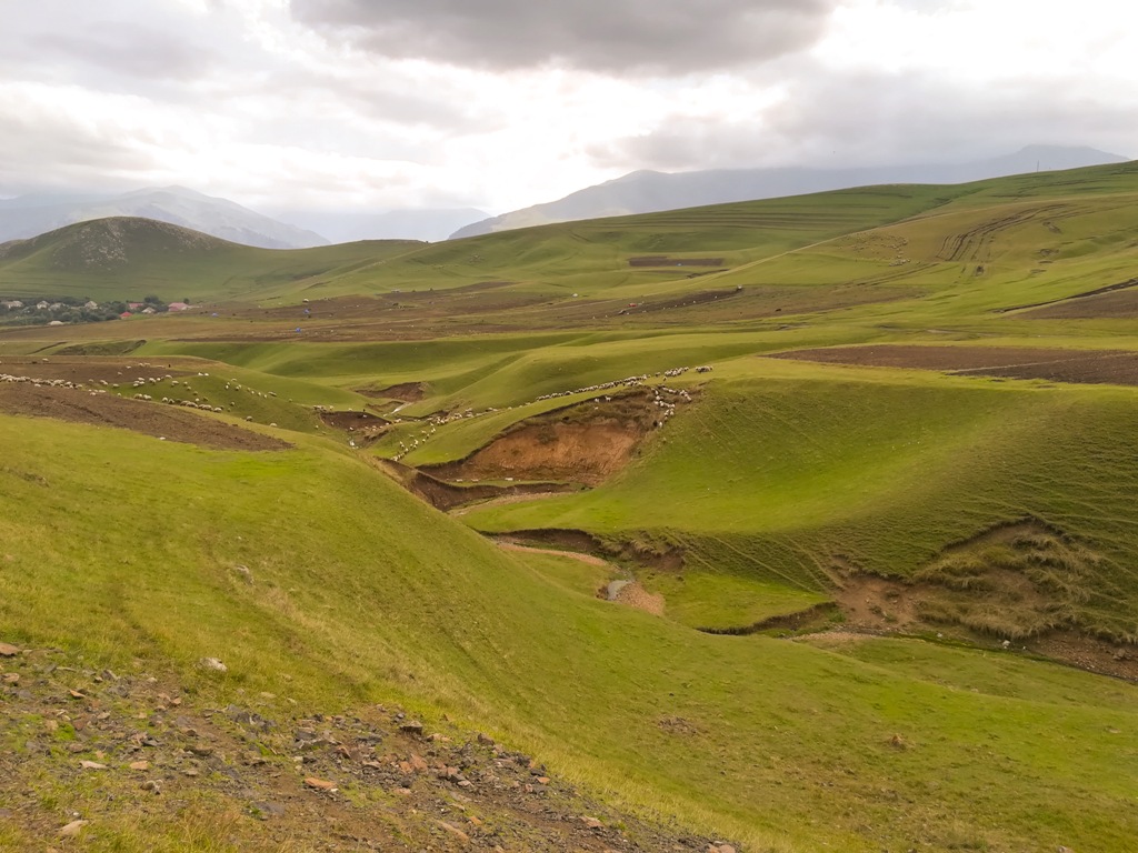
Whether the story is fiction, the route has been brilliantly designed. It is at perfect slope: The Mine location is higher and the Galakent Plant is lower in altitude. It inclines slightly and gradually with ease along the route.
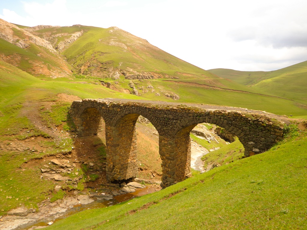
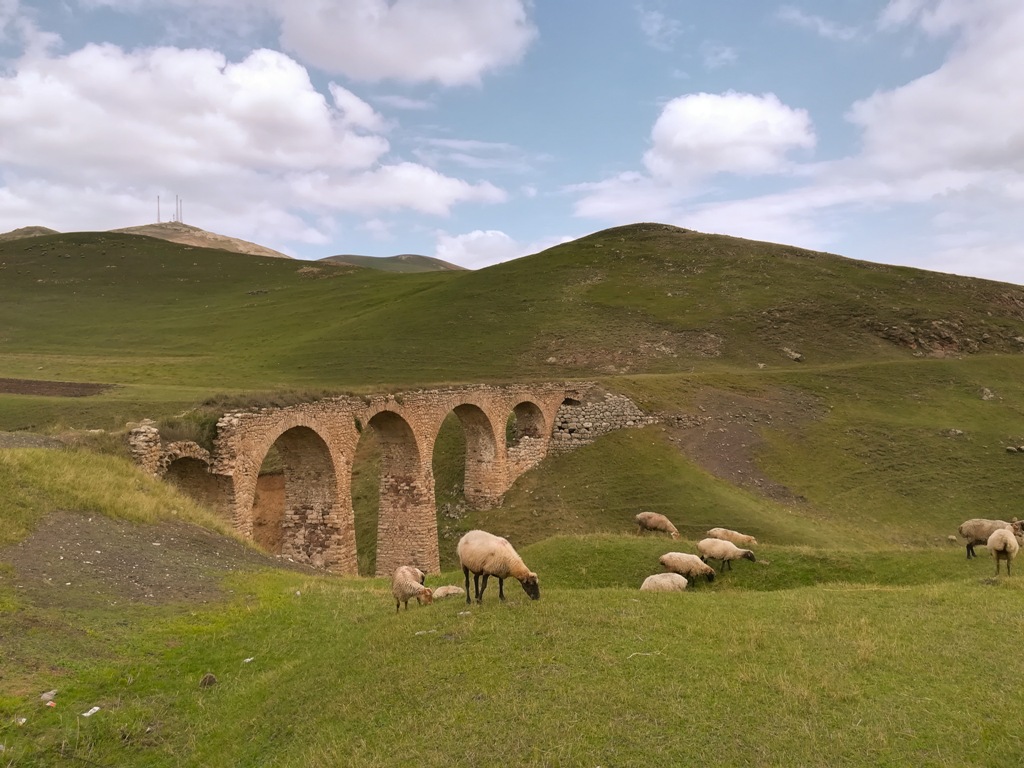
The landscape of the route is very complex. It goes through mountain downstreams and/or hard rock on ridge of mountains. On the downstreams, arch-bridges have been built. The largest bridges have 7 or 8 arches. On the ridges, they had to cut through hard rock with technology they were allowed at that time. I believe it was limited to pickaxe, however, it was high paid labour.
Today, one can observe more than 20 arch-bridges in various scales on the route. Some of the bridges are as the same as they were 100 years ago. But some of them are up to collapse from impact of downstream wash-away and human related destruction (see images below). Some of them are already collapsed completely and/or washed away with exception of columns or remnants of bridge parts in downstream bed.

The section of the route between Galakent and Duzyurd (till the last bridge of Duzyurd) is visible from satellite view of Google Earth. You just need to zoom in being able to see a disconnected long curved line. If you zoom in more you may also see shadow of arch-bridges.
Unfortunately, modern urbanization changed landscape making it impossible to determine exact path of sections of the route in all around the Gedabey city. Nevertheless, you can still discover dormant bridges, even copper ore while wandering in the mine area (the Copper Mountain) and the south-east part of the city where the Smeltery Plant located.
Hiking Tour of the Railway Route
– Get on a bus from Baku International Bus terminal (so-called Avtovaghzal) to Gedabey: Buses leave in morning at 0900 and in evening around 1800. It takes between 7-8 hours to get to the city. The bus will drop you right by the centre, in front of Bazaar.
– You will arrive in late in evening or early in morning. You can stay in Gedabey Hotel (so-called Mehmankhana) for 15AZN a night. The Mehmankhana locates in Avtovaghzal, 100 meters away from the centre.
– The best way of travelling the route is taking a taxi to Galakent, to the foothold of the Koroghlu castle unless you have plans of longer period of hiking with all necessary supplies. Then start the travel along the route back to Gedabey.
– You can catch a taxi (like a Bla-Bla car) for 1 AZN between 11:00 and 12:00 hours. Later than 12:00 you have very little chance to catch these periodic taxis as the Bazaar is getting over by noon. Otherwise you got to take a standard taxi which will cost you about 10 or 15 AZN.
– You get dropped by the Koroghlu castle. Voila!!! You see your first arch-bridge. Following track the road to your left and you are along route, though you will be walking through houses straight for about half a kilometre. But before all of these you may also enjoy exploring the castle up in the hill as well.
– You are better to take food, long raincoat and proper hiking shoes with you. I’d advise you also to print out the route images (see google link below) and check weather forecast at http://www.yr.no.
– People are friendly. They smile to strangers. Don’t shy away asking for guide.

Hints
You can walk/hike simply by following the route path which is easily recognizable from Galakent till the western entry of the Gedabey city.
If you fall into confusion, you can also carry on along the route by tracking slag spill along straight line. The way the route path chewed on the hard rock also gives you correct path of the route along your walk/hike. Thus there are signs of these kinds which allow you not to lose the tracking of the route.
In order to reach to the first (the third bridge on the map) in Chalburun, you have to get to the river bed. There will a door to your left allowing you to an orchard. Then ask hosts to let you through their orchard.
The link of Google map below gives exact location of route travelling from Galakent to Gedabey and those surviving arch-bridges. This is also very useful guide for you to make your way to Gedabey experiencing the narrow-gauge line.

Related Sightseeing Tours in Baku:
- Gobustan and Mud Volcano Tour
- Day Trip to Khinalug, Guba
- Baku Soviet Architecture Guided Walking Tour
- 5-Day Trekking in Greater Caucasus Mountains
Written by: Local Guides in Baku
www.azerbaijantraveller.com

2 replies on “XIX Century Gedabey-Galakent Railway: Historical Hiking Trail”
[…] To read more, check my blog post. […]
[…] Read more […]